Queanbeyan-Palerang is full of historic towns and villages with distinctive character. Nestled amidst picture-perfect scenery and spectacular natural parks, these villages are the perfect day-trip destination for locals and visitors in the Southern Tablelands region. This day’s drive will take you through some of the highlights of southern Queanbeyan-Palerang region all in one day. Marvel at the scenic landscapes of the rolling hills of Tallaganda and the calm countryside of Carwoola. Explore the history of the region’s old mining villages and discover local treasures in Braidwood.
On the road again
Your first destination, Captains Flat, is an old mining village nestled on the Molonglo River, among hills adjacent to the Jingera Mountains. The village is easily accessed from Queanbeyan by taking Bungendore Road east for about 4km, then turning right onto Captains Flat Road, and heading south another 45km.
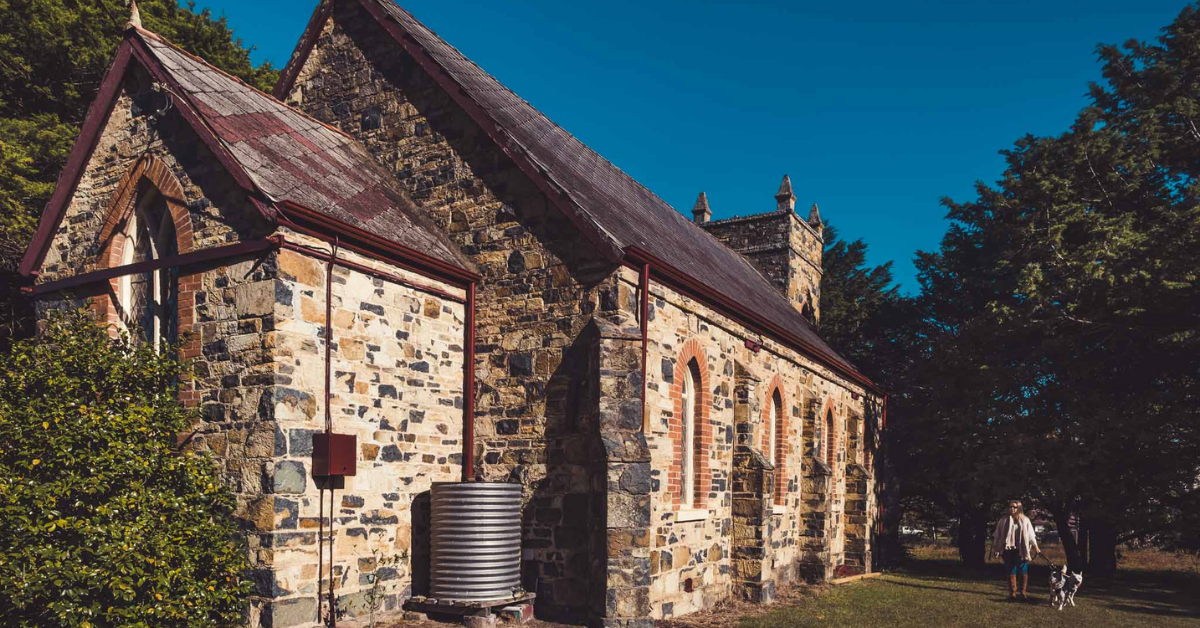
This road passes through picturesque countryside that features several notable properties such as Carwoola Station Homestead built in 1849, Foxlow Station and the traditional Gothic St. Thomas’s Church dating back to 1872, before reaching Captains Flat.
Captains Flat
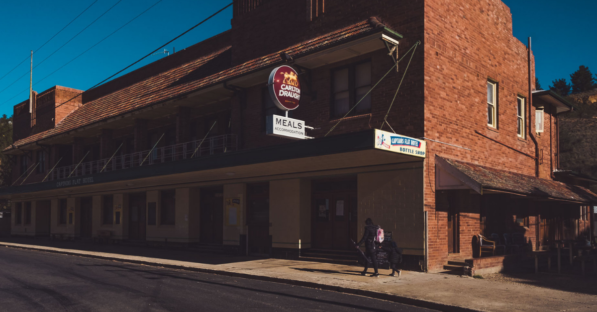
Captains Flat features an array of historic buildings and old mining sites. The origin of the name is said to come from a bull named Captain who was known to graze on the flat grassy paddocks near the Molonglo River.
The village was booming in the 1890s and again in 1937-62 as it became the major mining site in southern NSW. In fact, Captains Flat was one of the most important mining sites in the whole of Australia during this time, producing lead, zinc, copper, pyrite, silver and gold. This had a significant impact on the development and settlement of the area at the time.
Take a stroll around the village to explore its many historic buildings, such as the old hospital, former post office and Captains Flat Hotel, as well as attractions like the Miners’ Memorial.
Deua National Park
If you’re looking to explore the region’s national parks, depart Captains Flat and return to Captains Flat Route before turning on to Cooma Road. You’re now on route towards Deua National Park and the Big Hole walking trail.
The remarkable Big Hole is some 96m deep and 50m wide and can be safely viewed from a viewing platform over the hole. To get to the landmark, you will have to take a 3.5km walk from the Berlang campground. The walk can get rather adventurous as you will have to wade across Shoalhaven River along the way, therefore the track may become inaccessible as a result of higher river levels following periods of rain, so make sure to prepare well for your visit and take note of the weather conditions. After crossing the river, the walk continues through spectacular eucalyptus forest.
If you’re not in a rush, consider camping out overnight. The Berlang campground is ideal for bushwalkers looking to stay overnight.
If you’re staying overnight, spend the rest of the afternoon with a bushwalk to the Marble Arch, where you will see a boulder the size of a car. To get to the Marble Arch, follow the route through short caves and stunning slot canyons. Keep in mind that it is about a 5-hour return trip with low light at times, so carrying a torch is advisable. There is also a strenuous ascent/descent of stairs to consider before taking on the trail.
If you do decide to make the drive into a two-day trip, set up camp alongside Shoalhaven River after the big walk and take in the picturesque view before heading north towards Braidwood the next day.
When traversing through NSW National Parks, please make sure you always check the NSW National Parks website for the latest information on campground and track closures and conditions.
Majors Creek
To get to Majors Creek from Deua National Park, head back north on Cooma Road, turning right onto Wallaces Gap Road after crossing the Shoalhaven River. Follow the road until you reach Majors Creek.
First starting off as a retired soldier’s farm and then becoming a prosperous gold mining town, Majors Creek has gone through many changes over the years. Today, the idyllic village is a thriving community with a big heart, nestled at the top of Araluen Valley, a stone’s throw from the historic town of Braidwood.
Araluen
Nestled in the heart of the Great Dividing Range, in the Southern Tablelands of New South Wales, lies the beautiful valley of Araluen. Also known as the Valley of Peace or Happy Valley, the village is now noted for its picturesque scenery and calm, country atmosphere. In its heyday, the valley used to be one of the most famous gold mining towns in New South Wales.
Araluen is perhaps most well-known for its rich history of gold mining. Although your chances of finding any traces of gold are slim to none, gold panning at the picnic area beside the Araluen River is a great pathway to living the history of the village.
If you’re looking to make a longer stop in the valley, set up camp at the large and open Araluen Creek Camping Area, nestled at the foot of a mountain. The camping area has all the basic necessities for a free overnight stay and is even pet-friendly.
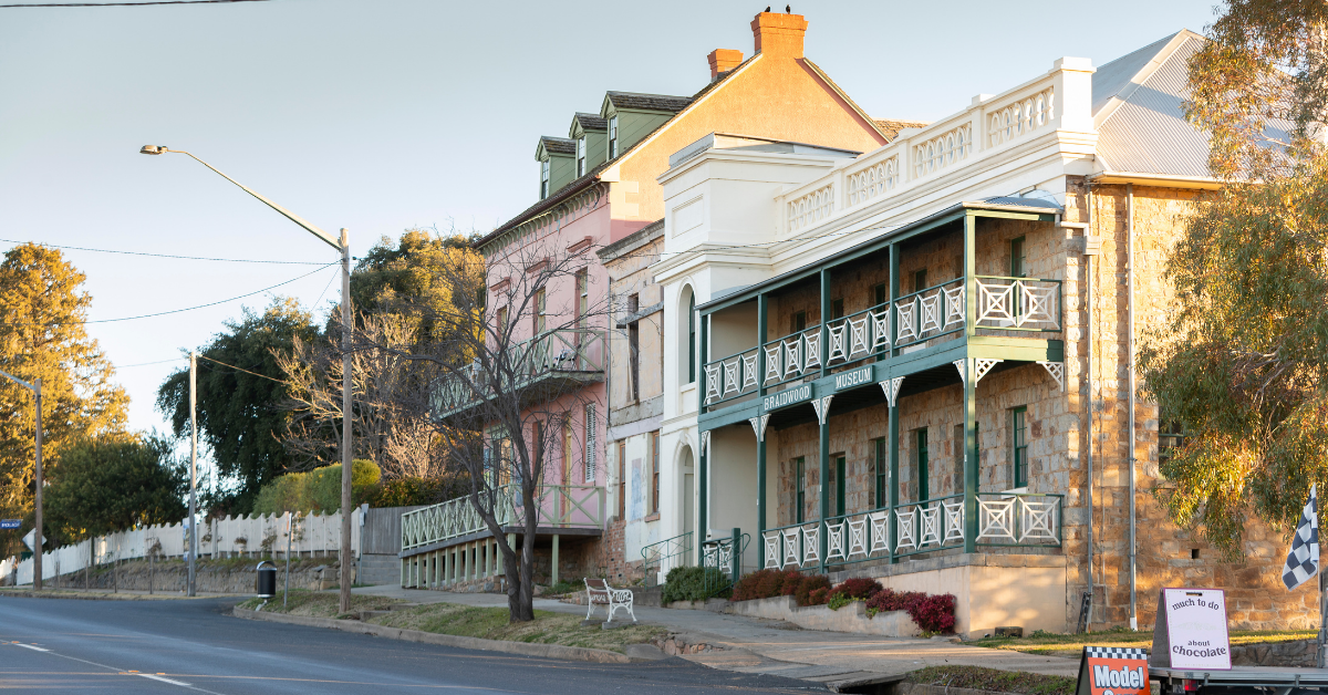
Braidwood
Follow the signs to Braidwood for your next country driving treat. The entire town of Braidwood is heritage listed on the NSW Heritage Register and it won’t take you long to figure out why.
The streets of the town are lined with charming old, colonial-style buildings. To get the most out of your trip to Braidwood, pay a visit to the Braidwood Museum where you can explore artifacts and photos from a bygone era, or take the Braidwood Heritage Walk to tour dozens of historic sites, right in the heart of Braidwood. Afterwards, discover local treasures by visiting the inviting boutiques and speciality shops in town before heading back home.
When travelling around NSW, please check Live Traffic NSW for the latest updates on potential road closures and conditions and the NSW NPWS website for alerts and closures of the national parks.